Views-A-Plenty at Arbol Solitario
There are some things that have been on my to-do list for years. Hiking up to Arbol Solitario (or Lonely Tree) has been one of them. You can see the tree, all by itself on a peak (or what remains of the tree), when you stop at the Jibaro Monument on Route 52 and look south.
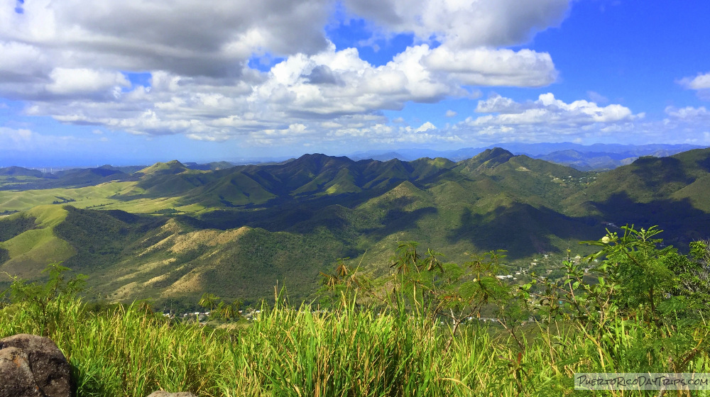
It is one of those places that reward you handsomely for your effort. The tree itself is not what makes the journey worth it. It is the photo opportunity that awaits you at the peak, which is almost 2000 feet above sea level. Located between Cayey and Salinas, you get some great 360° views of the mountains, surrounding towns, and the Caribbean Sea. Also called Cerro de los Cielos.

Not-So-Lonely Tree
In 2016, Trekking to this tree has become a very popular expedition. Of course, it is much better when you have the peak to yourself — to reflect, take photos, or just enjoy the bird’s eye views. But Puerto Rico’s beauty is to be shared with everyone, including 20 or 30 of your new best hiking buddies! But now in 2020, it is again a mostly solitary hike and arbol!

Our Hike
When we went, there were two trails up to the tree. The one that we used started on Route 52, on the north-east side of the mountain, but as of 7/16, this route is not allowed anymore. Currently, the only available trailhead starts on the south-west side of the mountain.

Note that the “trail” is not easy and it can be steep in places as you ascend. Almost the whole way to the peak, you are climbing dirt paths , through grassy areas. There is a gain in altitude of almost 600 feet. There are no handrails, ropes, or steps to make it any easier. It is at least a 90 minute walk/climb to the first peak, but most people will take longer. Take your time and be careful.
The trail was pretty obvious, but I hear now that fewer people visit, it is less obvious now! You will eventually get to the mango tree. It has 1 swing on it. The peak is up the trail a little bit and you will see the flag poles. The mango tree is nice for photos, but I think the photos from the peak are the amazing part of this trek. We stayed at the peak for about 20 minutes and then made our way back down to our car.

Details
Do not try to get to the peak from RT 52- you will get a parking ticket if you park on the emergency ramp or in the shoulder of RT 52 and try to go up this way. There is parking on the roadside on the Salinas side.
This hike is definitely rated as a difficult hike. You should think twice about doing this hike if you have mobility issues, cardiac issues, or are otherwise not in good physical shape.
Take water, sunscreen, hat, and your camera! Watch where you walk and place your hands. There are cactus with thorns along the path. We had no problem in shorts and hiking shoes. Definitely no flip flops!
For the safer parking area the only allowed access to the peak, take the other trail to the peak starting on the west side of the mountain, from a road off of Route 1 in Salinas. We found info about that trail head on the GeoCaching site, but we did not try to find it. It is a longer hike (maybe 1½ hours each way). I hear this is a safer and less steep route, but you need long pants/long sleeves for protection from the razor grass. The GPS coordinates for the Southside parking are 18.055479, -66.238724. Continue up the road on foot to reach the trail head (thanks EGHost!). I have heard the owner of the parking area now charges $5 per car which includes the use of his bathroom.
Click on a placename below to view the location on Google Maps ...
- Arbol Solitario, lower peak
- Arbol Solitario, parking
- Arbol Solitario, upper peak
- Jibaro Monument / Monumento al Jibaro Puertorriqueno
Puerto Rico Day Trips LLC assumes no responsibility regarding your safety when participating in the activities described in this article. Please use common sense! If your mother or that little voice in your head tells you that you are about to do something stupid … then don't do it!