Current Puerto Rico Weather & Storm Tracking
Quick Links: Weather Averages | Hurricanes/Storms
| Current Conditions Last Update on Apr 9 2026, 6:56 am AST | ||
|---|---|---|
78.8°F 26.0°C |
SAN JUAN A Few Clouds Winds Southeast at 4.6 MPH (4 KT) Currently feels like 82°F / 28°C Relative Humidity: 79% Visibility: 10.00 miles |
|
| 6-Day Forecast Last Updated on Apr 9 2026 @ 8:15 AM AST | ||
| Today Apr 9 |
85°F high / 83°F low Scattered Clouds |
|
| Fri Apr 10 |
86°F high / 86°F low Broken Clouds |
|
| Sat Apr 11 |
84°F high / 84°F low Scattered Clouds |
|
| Sun Apr 12 |
83°F high / 83°F low Light Rain |
|
| Mon Apr 13 |
82°F high / 82°F low Light Rain |
|
| Tue Apr 14 |
74°F high / 74°F low Overcast Clouds |
|
 Last Refreshed Apr 9 2026 @ 8:15 am AST | ||
When you’re planning a vacation, especially to a Caribbean island like Puerto Rico, you’re always watching the weather reports. That’s understandable considering the cost of airfare, lodging and any of your scheduled day trips. We’re providing the information and resources on this page so that you can see the latest weather reports for Puerto Rico as that big day gets closer.
What’s the Short-Term Forecast?
The graphic to the right shows the current weather conditions and the weather forecast for the San Juan area for the next week or so. You’ll notice that the average daytime temperature is around 85°F and it says there is a chance of rain almost every day. That forecast is normal for every day of the year! The temperatures will be a little higher along the coast, and a little lower up in the mountains. And rain … we’re in the tropics … it rains almost every day. But typically not "day-long downpours that will ruin my vacation" rain. Figure that you’ll experience short showers throughout the day, with clear, bright sunny skies in between.
Notice that typically the rain is scattered across the island and it moves in and back out pretty quickly. Again … not enough rain to ruin your day. Pack a small umbrella, or one of those raincoats that fold up real small, and you’ll be fine.
Even if it does rain, there are plenty of things to do around the island that you probably wouldn’t have done if it was a nice, sunny day. So take advantage of the less-than-perfect day and go to a museum or shopping.
If you want a more detailed forecast, the National Weather Service offers a comprehensive 7-day forecast for the San Juan area.
What Will The Weather Be Like In The Coming Months?
You’re probably looking at the current weather forecast from above and thinking "That’s really great that it’s sunny in Puerto Rico today. But what will the weather be like when I’m there on my vacation?"
That’s a really hard question to answer because the weather changes here like, well … the weather!
This table should give you some idea of what the typical weather is like in the month you’ll be visiting. It shows 30-year average high and low temperatures, 53-year record high and low temperatures, 52-year average relative humidity, average coastal ocean temperature, average rainfall, and approximate sunrise/sunset times on a monthly basis. So, even though we don’t have a crystal ball to tell you exactly what the weather will be, we can give you an idea of what to expect.
| Jan | Feb | Mar | Apr | May | Jun | Jul | Aug | Sep | Oct | Nov | Dec | |
|---|---|---|---|---|---|---|---|---|---|---|---|---|
| 30-Year Average High (°F) | 82.4 | 82.8 | 83.4 | 84.9 | 86.3 | 87.6 | 87.4 | 87.8 | 87.8 | 87.5 | 85.1 | 83.2 |
| 30-Year Average Low (°F) | 70.8 | 70.9 | 71.7 | 73.2 | 74.9 | 76.6 | 76.9 | 77.0 | 76.5 | 75.6 | 74.0 | 72.1 |
| 53-Year Record High (°F) | 92.0 | 96.0 | 96.0 | 97.0 | 96.0 | 97.0 | 95.0 | 97.0 | 97.0 | 98.0 | 96.0 | 94.0 |
| 53-Year Record Low (°F) | 61.0 | 62.0 | 60.0 | 64.0 | 66.0 | 69.0 | 69.0 | 70.0 | 69.0 | 46.0 | 66.0 | 59.0 |
| Avg Relative Humidity – Morning (%) | 81 | 80 | 77 | 75 | 77 | 76 | 79 | 79 | 79 | 80 | 81 | 81 |
| Avg Relative Humidity – Afternoon (%) | 65 | 62 | 60 | 62 | 66 | 64 | 67 | 67 | 67 | 67 | 67 | 66 |
| Avg Coastal Water Temp (°F) | 77 | 78 | 78 | 79 | 80 | 81 | 82 | 83 | 83 | 82 | 81 | 80 |
| Average Rainfall (inches) | 3.02 | 2.30 | 2.14 | 3.71 | 5.29 | 3.52 | 4.16 | 5.22 | 5.60 | 5.06 | 6.17 | 4.57 |
| Average Number of Days with Rain | 16.9 | 12.8 | 12.2 | 12.6 | 15.4 | 13.5 | 17.2 | 17.6 | 16.6 | 16.8 | 17.5 | 17.9 |
| Approximate Sunrise (AM) | 7:00 | 7:00 | 6:30 | 6:15 | 5:45 | 5:45 | 6:00 | 6:00 | 6:15 | 6:15 | 6:30 | 6:45 |
| Approximate Sunset (PM) | 6:15 | 6:30 | 6:30 | 6:45 | 6:45 | 7:00 | 7:00 | 6:45 | 6:30 | 6:00 | 5:45 | 5:45 |
| Temperature, Humidity & Rainfall Data from NOAA National Data Center. Coastal Water Temperature Data from NOAA National Oceanographic Data Center. Sunrise/Sunset Data from Astronomical Applications Department of the U.S. Naval Observatory. | ||||||||||||
What About Tropical Storms & Hurricanes?
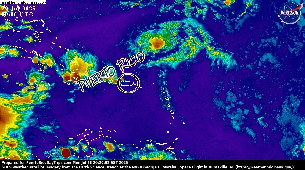
Every once in a while we’re unlucky enough to be in the path of a tropical storm or hurricane. Luckily, Puerto Rico is a small target and we usually get passed by. You can use the map below to see if there are any storms brewing in the eastern Atlantic or Caribbean areas that may be a threat to the island.
The weather map below is the latest Caribbean satellite map from the National Hurricane Center. This map shows current weather systems. For those of you that are geographically challenged, we’ve circled Puerto Rico on the map. Areas of the map that are dark blue are clear areas. Cyan and green represent clouds. As the colors change from green to yellow to orange to red the weather is getting worse.
Because they normally form far out in the Atlantic, storms typically move from right to left (east to west) on the map. So something to the right (east) of Puerto Rico may become a problem for us, while something to the left (west) of Puerto Rico is usually not an issue.

Large circular areas of yellow/orange with a red center may represent either a bad storm, tropical depression, tropical storm or hurricane. If you see those on the map, you might want to take a look at the more detailed storm information from the National Hurricane Center, or this animated map from The Weather Channel.


