Laguna Guaniquilla Reflections

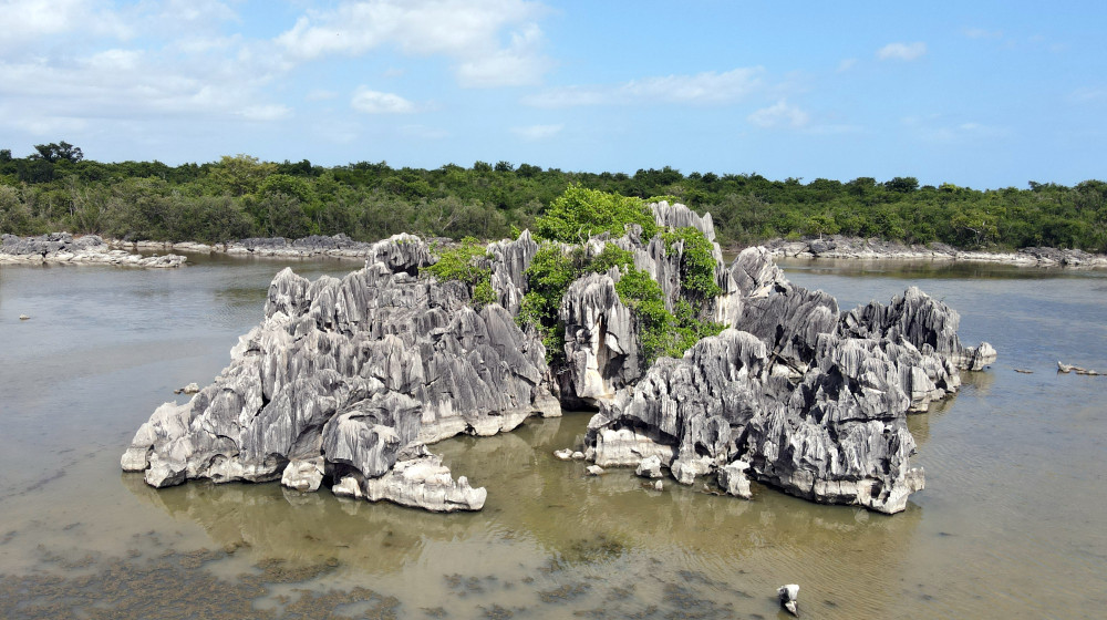
When I first saw a photo of Laguna Guaniquilla, I knew that I had to find it myself. Huge, jagged rocks that look like they came from the moon in the middle of a lagoon … you don’t see that every day! It was so unusual looking — hauntingly beautiful and roughed. A photographer’s and hiker’s dream, but with just one catch …
Laguna Guaniquilla is located in Cabo Rojo, on the south western point of Puerto Rico. A local, that lives in Cabo Rojo, gave us the info on how to go in to see this … “if you are into adventure”. Well, we are. So we did!
I was expecting a rough trail, but it was amazingly easy. Beautiful, cleared paths; even a boardwalk in one spot. Ruins from 19th century hacienda. And caves.

Well, it turns out this whole area is a nature reserve — “Punta Guaniquilla Nature Reserve” — maintained by the Fideicomiso de Conservación de Puerto Rico (Puerto Rico Conservation Trust).
They have walk through gates in 2 places, so people can enter and walk around. The trails are wider and maintained and they have put up signs of the route to the lake and the caves and the ruins etc! Enjoy but keep it clean!
Our Morning of Adventure
We visited Laguna Guaniquilla the same day we that we went to Playa Buyé. At the tee at the end of Calle Buyé, we turned left (turning right leads to the beach), and followed the dirt road until we got to a gate. You should be able to walk around it. If not, you can find a hole in the fence and walk up along the road.
We went during rainy season, so it was a bit muddy. Luckily, we remembered to bring insect repellent, otherwise we would have donated a lot of blood to the mosquitoes!

It is a nice walk, maybe about 20 minutes until we got to the ruins of the 19th century sugar hacienda. The ruins are beautiful, and the view behind them is amazing. From this vantage point up on the hill, we could see the limestone rocks in the lagoon below.
At this photo spot, you will see signs for the trailStarting here, you will get to the cave first and then can continue on to the path around … as it turns out, it is a big circle.
When we first went, there were no trail signs, but our Google Maps on our iPhone worked well, so with the signs and a map, you can’t get lost!

The path was really muddy, but mostly flat and easy walking, until we got to the limestone rocks. I thought they looked like giant dinosaur bones — stark white with jagged edges. The path leads through the rocky area, but there were times where the path was just across the rocks, so it was a bit more difficult. Note — sturdy shoes are required, no flip-flops nor water shoes.
After a while, we got to a “cave area” that was also neat, with huge rocks leaning against each other — as if some giant had knocked over a bunch of dominoes.
Finally, we got to a place where the path led through an opening and to the edge of the water.

After about another 100 photos, we continued on the main path. The path lead away from the lagoon, through the mangroves, and along the beach. It was all just beautiful.

Detail
Laguna Guaniquilla is on private property of the Fideicomiso de Conservación de Puerto Rico (Puerto Rico Conservation Trust) they allow people to enter. The Fideicomiso sometimes offers tours of Laguana Guaniquilla – check the schedule on their web site. Though, they do have an official gate that is open all the time for people that want to hike, so I assume it is ok to go in and explore the area. You will find the “Porton” on Google maps, off of Rt 307.

Make sure to protect the environment. Take only photos. Leave only footprints. Stay on the trails. Bring plenty of drinking water, and insect repellent. Sturdy-soled shoes are required, no flip-flops.
It took us about 2 hours from start to finish.
To get to Buyé Beach, once in Cabo Rojo, take Road 307 to KM 4.8. That’s where you’ll find Calle Buyé. Park along the street or in one of the lots. Walk to the left at the T at the end of Calle Buyé.
Click on a placename below to view the location on Google Maps ...
- Laguna Guaniquilla, Gate on Path
- Laguna Guaniquilla, photo spot
- Laguna Guaniquilla, trailhead by ruins
- Laguna Guaniquilla, trailhead in field
- parking, Buyé Beach
- Playa Buyé
Puerto Rico Day Trips LLC assumes no responsibility regarding your safety when participating in the activities described in this article. Please use common sense! If your mother or that little voice in your head tells you that you are about to do something stupid … then don't do it!