Dramatic Cliffs and Arches in Cabo Rojo
The road to the lighthouse is never good. Sometimes it can be in REALLY bad shape. Currently it is closed to vehicle traffic. But you can park at gate and walk in about 1.25 mile to lighthouse and the beach. It is a hot, long walk- about 30 mins. Make sure not to block road or gate when parking. Best to get there early. NEVER LEAVE ANYTHING OF VALUE VISIBLE IN TH CAR!. Last we went, the first car was broken into, ours was not…I assume they had something interesting visible.
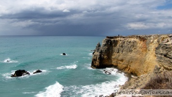
I consider the cliffs of Cabo Rojo, near the lighthouse, to be one of the most beautiful places in Puerto Rico. We have found that, as you explore the area around the lighthouse and head northwest, you will see how these rugged cliffs have been worn and sculpted by the ocean waves over time. There are all sorts of arches, little caves, and other amazing rock formations along this coastline. The photo opportunities are endless!
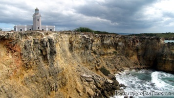
Cabo Rojo is located in the south-western corner of Puerto Rico. To get to the cliffs, you first need to head to the Cabo Rojo lighthouse. We have explored this area in the past, but we have usually gone to the east, toward La Playuela Beach.
But recently, I saw a picture of a natural bridge (arch) in Cabo Rojo, and I knew that I had to find it! As it turns out, this natural bridge, and many other beautiful rock formations, can be found found by following the small trails to the northwest of the lighthouse (that would be to the right if looking at the ocean with the lighthouse behind you).
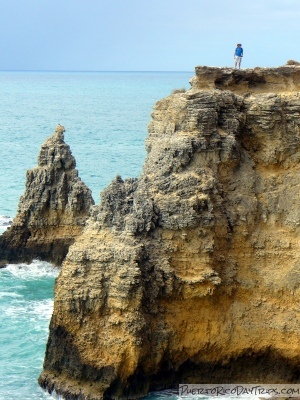
Caution! The cliffs around the lighthouse represent a danger to anyone in the area. This isn’t a National Park. There are no railings to keep you from falling over the edge and into the ocean. A couple of people meet their maker every year in this area (seriously!). If you survive the fall, you’ll probably drown in the ocean. The memorial markers at the cliffs’ edges should remind you to stay a safe distance from the edge. The limestone is fragile and it is prone to breaking off. What seems like sturdy ground may actually only be a couple inches thick with nothing but the ocean below. There are also open holes in the limestone that go straight through to the ocean, so watch your step as you’re walking around. We don’t recommend that anyone try to go out onto these rock formations. If you go to this area, use common sense and don’t be stupid.
The Natural Bridge
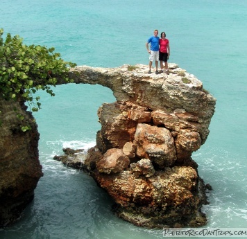
As you walk up the driveway from the road to the lighthouse, just before the “road” curves up to the left, you will notice a path that leads to the west (to the right). This one will get you to the rock bridge.
We did not take this path originally, but you can get to the rock bridge by turning to the right just past the light house and follow the little trail . You will eventually see the cove with the arch.
They have a gate and sign prohibiting people from going out onto the bridge. The bridge part that connects the rocks is only about 3 feet wide in the middle — it’s a little bit scary and a big bit dangerous. We do not recommend that people attempt to go out onto the natural bridge. Look, take photos, and admire it from the safety of solid ground.
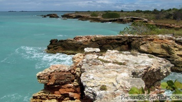
Besides this cool arch, there are all sorts of little caves, blow holes, and other formations. We spent a couple hours just exploring this area along the coastline path. As you walk more toward the north, the cliffs get shorter and shorter until you are eventually able to step right onto the beach. But watch out for the waves!
<
Be warned that there are loads of tiny, unmarked paths (made by mountain bikers) that criss-cross all over this area. We used Google Maps on our iPhone to help us figure out when to turn to the east for the shortest trail back to our car.
Details
To get there, take Route 301 in the Cabo Rojo area all the way to the end.
Click on a placename below to view the location on Google Maps ...
- Cabo Rojo Lighthouse
- Cabo Rojo Lighthouse / Faro Los Morrillos, parking
- Cabo Rojo Natural Arch
- La Playuela Beach
Puerto Rico Day Trips LLC assumes no responsibility regarding your safety when participating in the activities described in this article. Please use common sense! If your mother or that little voice in your head tells you that you are about to do something stupid … then don't do it!


