Hike the El Yunque Trail to the Top of the Rain Forest
The last part of the trail (to the peak) is closed using the El Yunque trail. To go to the peak, you can start via Caimatillo trailhead from 191 but will need to cross over Mt Britton Spur (or just use Mt Britton Trail up to RT 10) and then walk up the road 10 by Mt Britton Tower. Info on other trails mentioned in this article: Los Picachos Trail and La Roca trail are opened!. But Bano del Oro trail is closed
 .
.
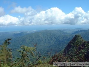
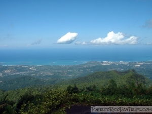
On a clear day, the view from the top of El Yunque is breathtaking. Looking out over the lush green tree tops, past the towns, you see the blue water of the northern coastline and the easternmost tip of Puerto Rico. You know you are pretty high when the clouds come rolling up the sides of the mountain toward you. You feel the refreshing cool mist of the clouds on the wind cooling you off from your hike up the mountain. It is a real reward for your hard work!
Here is my usual route: The trip to the El Yunque peak takes you through different levels of the forest. You will notice the changes in the plant life as you walk along. You start in the Palo Colorado Forest that has many trees of different types (including the Colorado tree). As you go upward, about in the area where you pass the junction with Mount Britton Spur, you will be in the Palma Sierra area (lots of palm trees). Toward the top, you will notice short, shrubby moss covered plant life – the Dwarf Forest.
Along the way, you will be crossing many mountain streams, seeing beautiful plants and flowers like fern trees, bromileads, impatient and hibiscus flowers. Be careful – it is easy to mis-step as you are looking at all the beautiful plant life around you. You will also be hearing many different types of birds, insects and frogs (including the beloved Puerto Rican coqui!). Just don’t expect to see the Puerto Rican Parrot. There are only about 33 left in the wild and they are rarely seen.
There are a number of ways to start out your journey toward the Peak of El Yunque. Our favorite (and most scenic) way is not yet reopened….to take the El Yunque Trail, which starts on Road 191 at KM 12, across from the Palo Colorado Information Center. From the information center, cross Road 191 and walk up the concrete steps. Go to the top of the steps and check out the Bano Grande pool. This pretty pool was developed as a natural swimming pool, but swimming has been prohibited for many years now. There are informational placards explaining the pool and its history. You can get some lovely pictures here, and the water cascading down the rocks sounds lovely. Start at Caimitillo trailhead (km 11.8 on rt 191), but you will take it for only about 500 yards. Soon you will see the closed off trail junction for the El Yunque trail on the left. Turn right and start your journey.
I think this first part of El Yunque trail is the hardest (or maybe it just seems like that because it is steep and you’re not yet warmed up). Shortly, you will come to a junction at a rain shelter. You want to continue straight up El Yunque trail (do not go right).
After a while, you will pass the junction point with Bano De Oro trail to the left (this trail is still closed). You want to continue straight up. You will pass about 2 more rain shelters. After a while, you will come to a T at a rain shelter with a fireplace – this is the junction with Mount Britton Spur trail.
Here you have to make a decision – taking the road up or going through the forest. If you are pressed for time, go to the left and take the Mount Britton Spur trail to Road 10, then turn right on Road 10 and follow it up to the peak. Taking the road is quicker, but not as pretty as going through the forest. I like going to the right and continuing along El Yunque trail.
I’m going assume that you decided to go to the right and continue on the El Yunque trail to the peak.
Following the El Yunque trail, you will eventually come to a junction with Las Picachos trail. El Yunque trail is UP to the left (the sign oddly does not point out the trail to the peak). If you have time, take the short Las Picachos trail – it is very short and the views are really nice toward the east shore. But it is an out and back. So after admiring the view, come back and continue on the El Yunque trail toward the peak. At this point, the trail gets a bit rough and less maintained. But I still think it is still very doable.
You will get to a point where you will think you are at the top because it is kind of flat and the wind is blowing and one can carefully go out onto the rock on the right for great views and pictures. But it is a rock on the edge of the world- be careful!
At this point, you are almost to the peak, but you still have some more upward climbing to do!
The El Yunque trail will eventually come to Road 10. When you get to the paved road, turn left and walk up the last really steep part to the top. Walk up the steps of the Observation Tower. Once you are on the top, you have made it to the peak!
The Observation Tower at the peak looks like an old church inside (with a Cross engraved in the stone) and a castle from the top with parapets. It makes a neat picture! One drawback is there are a number of communication towers along the peak, so your view to the west is marred by antennae. But on the plus side, you get really good cell phone reception up there!
On the way down, I like walking down Road 10 a little bit. Look for the marker for La Roca trail to the right (behind one of the communication stations). This short trail is not well-maintained, and there’s a small rock wall that you have to climb, but if you are daring enough to walk out on this rock that hangs over the edge of the world … wow! … the view is great, but not really safe!
Continue down Road 10 until you get to the Mount Britton Spur trail. If you want, at this point you can go up to the Mount Britton tower – it is a really quick stop. Then continue on the Mount Britton Spur trail, which will take you back to the El Yunque trail (by that fireplace you passed on the way up). Then take the El Yunque trail down (to the right) toward Road 191. Here you’ll be walking down the way you came up at the beginning of your trek. When you get to the junction with the Bano De Oro trail, turn right and follow that trail back to Road 191. Once you emerge onto the paved road, turn left and walk down Road 191 a short way to the Palo Colorado information center. Currently Bano de Oro trail is closed, so you have to just go straight down as you came up to Caimatillo.
That is a well rounded trip to the peak of El Yunque!
The El Yunque trail has a difficulty rating of moderate to challenging. It has some parts that are more difficult than others, but really not that bad. If you follow my suggested route, you’ll cover almost 5 miles round-trip, with a rise in elevation of almost 1500 feet. The round-trip takes about 3 to 4 hours, all depending on your fitness level and how much you want to admire the scenery. The trail is steep and muddy in some areas. There are a few rain shelters along the first half of the hike, the second half might have one (I can’t recall at the moment).
I like to try to get to the peak before noon so you have a better chance of getting a clear, panoramic view. We have found that the clouds start rolling-in in the afternoon and they block the view, which is a bummer after hiking all that way!
Bring a snack (or lunch) and something to drink – you will need something during this hike to keep your energy up. We like taking our lunch up and eating it at the peak – there is no restaurant anywhere in the world with this view!
Parking for El Yunque trail is available in two paved parking lots adjacent to the Palo Colorado Visitors center and at designated areas along the road.
If you’re really pressed for time and you really just want to get to the peak, you can forget about the trails and just walk up, and back down, Road 10. This way is quicker, but much less scenic. If you want to do this, you can drive up Road 191 until it ends, and then park in designated areas along the road. Then you can either
- walk up Rd 191 and turn right onto Road 10 and walk all the way up. It is about 1.6 miles to the top on a steep and sunny road.
- turn right on Road 9938 and park at Mount Britton trail head, hike that up to Road 10, then continue on Road 10 to the peak. You will be walking about 1 mile up a pretty steep (and sunny) road.
It is important to remember where you parked – and plan your trip so you end up back at that spot, or you could be in for a longer walk than expected! The Forest Rangers can help you with that – stop at the Palo Colorado Visitor Center and talk with them.
Details
There is no cost to hike in the El Yunque National Forest.
El Yunque National Forest is open 8:00am until 5:30pm 7 days/week, year-round . Ranger stations are open 9:00am until 4:00pm. The gates close at 5:00pm.
The round trip from the Palo Colorado information center to the peak of El Yunque takes about 3 to 4 hours.
You can call 787-888-1810 or 787-888-1880 for more info.
You can visit the El Yunque National Forest web site for more information.
There are signs pointing to the rain forest. If coming from SJ, once on Rt 3, go until you see a small sign for RT 191 (and the rain forest). Turn right there, or if you miss that, turn at the corner intersection with Route 955. Follow Route 955 to Road 191. Turn onto Road 191 (there’s another sign for the rain forest here) and you’re there!
The drive from the San Juan area to the El Yunque National Forest takes about 45 minutes.
Click on a placename below to view the location on Google Maps ...
PuertoRicoDayTrips.com assumes no responsibility regarding your safety when participating in the activities described in this article. Please use common sense! If your mother or that little voice in your head tells you that you are about to do something stupid … then don't do it!