Northeast Ecological Corridor – Beaches, Nature, and More

The Northeast Ecological Corridor, or the Corredor Ecológico del Noreste (in Spanish), is a wonderful stretch of coastline, from Luquillo to Fajardo. The area had been designated as a nature reserve to make sure that this important natural area would always always be there for future generations.
The Area
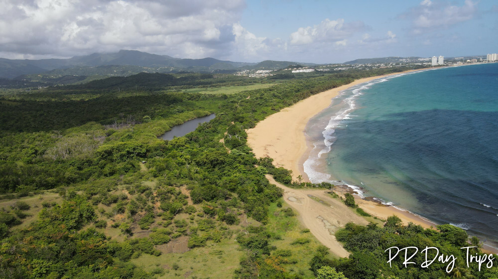
Running from the eastern end of La Pared Beach in Luquillo to the western edge of Seven Seas Beach in Fajardo, the Northeast Ecological Corridor covers more than 3200 acres, and has 13 miles of coastline. The area includes beautiful beaches with healthy coral ecosystems, wetlands, forests, dry forests, mangroves, and a seasonal bio-luminescent lagoon (Laguna Aguas Prietas).
Many species of mammals, birds, reptiles, and amphibians call this place home. Some of them, like the Puerto Rican boa constrictor and the West Indian manatee, are endangered species.
This area is also one of the most important nesting site in Puerto Rico for the critically endangered leatherback sea turtle, and it is one of the top nesting sites in all of the US. Besides the wildlife that enjoy the area, many people come here to enjoy walking on the beach, bird watching, fishing, or surfing the waves..

A Long Walk on the Beach
It was overcast one April morning, so we decided it was a great day for a beach walk. We parked at La Pared, walked east to the end of the malecon, and walked down the steps to the beach. Once on the beach, we crossed a rocky area by the Sandy Hills Condos, crossed the river and we walked … and walked … to the east. The first area that we came to had big surf and is generally unsafe for swimming. This is Playa San Miguel. We continued past marshes and wooded areas.

We also passed a number of leatherback turtle nests. As you can see from the tracks, they are large animals! The turtle season runs end of March until mid September.It is really important to avoid walking on the tracks or in the disturbed nesting area, as the DRNA does studies of them.
The nests were fresh and unmarked, but as we continued on, volunteers from the DRNA (Puerto Rico Department of Natural Resources) came by marking and documenting each nest. We also saw a few older, marked nests from March. It is really important not to disturb these nests, or if you are lucky enough to see a turtle laying eggs or the hatchlings, DO NOT go near them. Besides being illegal to touch/bother them in any way, it is important to let nature be. If you see a turtle in trouble, please contact: Rosaly Ramos- (787) 635-4493 (who is the DRNA biologist in charge of the Turtle conservation in the NEC), The Luquillo Police (787) 889-2727, or the DRNA offices (787) 771-1124.
At about the 2 mile mark, we passed La Selva where the surfers love it. Then continuing around the point, we found camp sites just off the beach and a nice reef for snorkeling. It looked like a reef was protecting the beach from the waves, it is generally safe to swim, but be aware of rip currents!
This area at La Selva is SOMETIMES accessible with a 4×4 via a dirt road. The road starts off RT 3- look on Google Maps for “Finca San Miguel”. This road can get really bad- don’t try it in a regular car or after it rains!
After this we continued on walking another 0.5-1 mile, we eventually got to a another beach. This area is called Playa Las Paulinas. Again, this area is very active turtle nesting, so be careful where you step. This is were we sat, had our lunch, and enjoyed the beach and looking water (and the sun, which finally came out for us). The day we went (mid-week), no one else was there, so we had plenty of beach to enjoy.

The beach goes on and on, eventually you come to Playa El Convento, Governor’s Beach, Playa Escondida, and (after a walk through a wooded area) Balneario Seven Seas.
Info
While the Sierra Club/DRNA and other collaborators want the whole area to be a nature reserve, they do realize that people should be able to enjoy the area. Currently, they have improved one dirt road that leads from Route 3 into the Northeast Ecological Corridor. Located on a “marginal” off RT 3, (near Route 940)- look on Google Maps for “Finca San Miguel”. The first part is a decent road. It is generally a 1.5-2 cars wide at this point. It leads down to a T, where most people will turn right to get to La Selva. But believe me- This next section of the road can get really bad- don’t try it in a regular car or after it rains! And it is only 1 car wide, so you may need to back up, or go in the grass or bushes to let someone pass. But if you can make it, it goes to the surfing area and beyond that, to the camping area. If you are going to walk or bike, I suggest you just park at the T.
There are trails for biking and walking around the area, so you can bird watch or just get to the beach.
Remember this is a turtle nesting area- do not drive on the beach, do not make fires, pick up your trash!
I was talking with a Sierra Club member, and his safety suggestions included not to leave anything of value in your car if you drive in to go to any of the beaches in the Northeast Ecological Corridor, not to walk alone on the beach here, and not to visit the area at night. There have been a few unfortunate incidents.
Future plans

The Sierra Club and its coalition partners are working on eco-friendly projects that will help educate people, keep the area preserved and help make jobs and generate income for the local area. Right now there is a kayak tour of the rivers.
The area is open to visits. On our walks we saw a lot of trash during our walk along the beach, some of it washed up on shore, but a lot of trash was simply left behind by beach goers. If you visit the area, please carry out everything that you bring into the area, including any trash you might make while there. Also, consider bringing along an extra trash bag and picking up 1 bag full of trash that you see on the beach. Every little bit helps!
Details
For safety reasons, I would only recommend visiting this area during daylight hours, and I would not visit the area alone.
There are no lifeguards at any of the beaches inside the Northeast Ecological Corridor. Swimming is completely at your own risk.
Be aware of rip currents that occur frequently along the north coast. If you don’t know how to spot a riptide, or if you don’t know how to get yourself out of one should you get caught in one, then you have no business going into the water!
During times of high rainfall, some of the streams that lead from the mountains to the ocean become rivers. That means that a walk down the beach might require wading through waist or chest-deep water. This water can have a strong current and can sweep you out into the ocean.
Click on a placename below to view the location on Google Maps ...
PuertoRicoDayTrips.com assumes no responsibility regarding your safety when participating in the activities described in this article. Please use common sense! If your mother or that little voice in your head tells you that you are about to do something stupid … then don't do it!