Hiking and Exploring Cueva Alta in Río Abajo Forest
Update 1/26, they have not re-opened or maintained this area- finding trail is difficult, use at own risk (ALLTRAILS has it mapped out) . Campgrounds are still closed. Try the hike to the Cueva Del Agua in this forest instead.
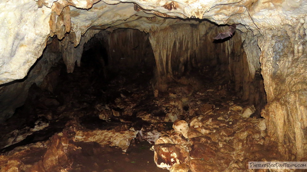
Safety note- This cave has a thick layer of bat guano in it. It is possible that by disturbing the guano you are exposing yourself to spores of the fungus Histoplasma capsulatum, which can cause acute pulmonary histoplasmosis (a respiratory infection). Use of a face mask/respirator would probably be smart idea when in this cave.
If you like to hike (like we do), then you will want to check out some of the forests in Puerto Rico, beyond El Yunque National Forest. As it turns out, the Río Abajo State Forest is pretty interesting, and it has some good hikes that will appeal to bird-watchers and people who enjoy exploring caves. It used to have a really nice camping area, but it is now abandoned and unusable. This forest is well worth a visit!
We have been trying to hike in Río Abajo Forest for years. We read in travel guides and online sites about the many wonderful trails available in the forest, but we could never find any definitive info about those trails. A number of years ago, we stopped in at the forest manager’s office and asked about trails and hiking. The forest manager told us there were no trails, and that the forest was not being maintained. Bummer!
Fast-forward a couple years, and after talking with people that camp there with the Boy Scouts, we were told that there are trails near the camping area. So we recently got into the car and drove out there again to check it out.

Río Abajo Forest
Río Abajo Forest (Bosque Estatal de Río Abajo) is located in the towns of Arecibo and Utuado, in the karst region of the island. Located toward the center of the north-west part of the island, the forest is less than 1½ hours from San Juan, not too far from (These two are currently closed- the Arecibo Radiotelescope, Lago Dos Bocas) , and Cueva Ventana. There are a lot of things to do nearby, and you could easily spend more than a day in the general area.
This forest system is managed by the Department of Natural Resources (Departamento de Recursos Naturales y Ambientales). The forest itself is quite large, has rivers and streams running through it, caves, interesting karst rock formations, and a campsite. It also is home to many animals and trees. The José Luis Vivaldi Lugo Aviary, where they have a breeding program for the endangered Puerto Rican Parrot, is located in this forest.
A Hike, a Picnic, & a Cave
On our recent visit, we stopped by the Forest Manager’s Office to inquire (again) about trails and facilities in the forest. The office was not open, so we just continued to the camping area, parked on the road (near the gate that blocks the road), and decided to figure it out on our own.
This was a reconnaissance visit for us. We wanted to see what (if any) trails we could find, and we had GPS information for some caves that we were going to try to find.
We walked into the camping area, and then followed the concrete path past the restrooms. The path eventually deteriorates to dirt/rocks as it goes downhill — looks like the rain water has chewed it up pretty well. This “trail” is a large loop that eventually ends back on Road 621 (beyond the locked gate where we parked). The trail is not really “maintained” — some areas were great, wide-open paths (probably part of the old logging trails), while some areas were just a tiny footpath through the weeds. Even so, we didn’t have trouble following the path. Hiking this loop took us about an 60 or 90 minutes. The trail itself should be doable by most average hikers.
Along the trail, we saw many different types of trees (some where marked to identify their species), flowers and plants, some neat birds, though none of the released PR parrots (we were listening for their calls).
At the end of the trail, where it meets up with Road 621, there is a sign from an Eagle Scout project for a hike to a cave called “Cueva de Agua”. We didn’t have time to do it, but we will be back. It looks like that trail is maintained, a bit longer, and an in/out hike. See our article Cueva del Agua
The cave we were looking for, “Cueva Alta”, was supposed by be near the picnic area where we started out. Even though we had the GPS info for the cave, we weren’t using our GPS (D’oh!) so we missed it by a mile.

After hiking the loop, we got back to our car, grabbed the sandwiches we packed for lunch, and had a picnic in one of the pavilions in the camping area. During lunch, we reviewed our notes, and realized that we walked right past the trail that leads to Cueva Alta!
So, after lunch, we tried again. From the camping area, we walked down the concrete path past the restrooms (again), and onto the main trail. Once the concrete ended, it took us about 4 minutes (seriously!) to get to the side-trail that leads to the cave.
Here’s how to find it … After the concrete ends, walk about 4 minutes. After the initial descent, you’ll see palm trees and a little stream to the left of the main trail. The main trail curves to the left, and in about another 15 seconds you’ll see marker tape for the “trail” (more like a worn path) that leads up to the right from the main trail. You can see a rough trail up to the cave.
Depending on your speed, if you’ve walked more than 5 or 8 minutes beyond the end of the concrete path, you’ve missed the side-trail to the cave.
This path up to the cave is not easy to do, but it is worth the effort. It looks like the swallows nest on the outside of the cave, and the bats sleep on the inside. You can see some small petroglyph “faces” on the outside, and just inside the mouth of the cave. If you have flashlights, you can try checking out the cave. Be careful in the cave, it is slippery, dark, and there is bat guano on everything. The cave has some neat formations inside and goes back pretty far. If you continue to the back, it slopes down, makes a U-turn, and heads back toward the mouth of the cave, but on a lower level.

Camping
We should mention that there WAS a really nice campsite here in the forest. If and when it ever reopens, you would need a permit from the DRNA. It is a slow process to get permits (do it a few weeks ahead of time). You can either go in person to the DRNA office in San Juan to out the paperwork, or you can fill out this paperwork, mail it to them (along with a check), and they will mail the permit to you.
You should talk with the San Juan office to check the dates you want ahead of time and to find out if/where you need to pick up a key to the gate/restrooms, and when/where to check in.
The DRNA San Juan office is located on Carretera 8838, KM 6.3, Sector El Cinco, Río Piedras (just down the road from the UPR Botanical Garden). They are open Wednesday to Friday, from noon to 4:30pm. If you plan on going to their office, call ahead to double-check their hours … (787)999-2200 Ext 5156, 5110 or 5158.

Details
The Río Abajo Forest is open for hiking from dawn to dusk. Camping overnight requires a permit.
Bring plenty of drinking water. Though there are water faucets in the camping area, it’s not potable water. Wear appropriate footwear (sneaker or some type of hiking shoe).
There is no cellular service in the area. If you are depending on GPS that requires cellular service (like Google Maps) … it’s not going to work. Your best bet would be to download a GPS/compass app for your smartphone that doesn’t require an internet connection to work. For our iPhones, we use iArrow and Commander Compass.
The Río Abajo Forest Manager’s office is on Road 621 KM 4.4 (approximately). If the office is open. you can stop in and see if they have any info on other trails, or trail maps. I would love to know if there are other trails.
To get to Río Abajo Forest, take Route 22 to exit 75b, then Route 10 south to KM 67 (approximately). Then take Road 6612 to the end, then turn left onto Road 621. Follow Road 621 to the end (KM 7.4), and park on the side of the road, being careful not to block the road or any of the gates. You can enter the camping area to the right of the fence.
Click on a placename below to view the location on Google Maps ...
- Cueva Agua (Rio Abajo Forest) front entrance
- Cueva Alta (Rio Abajo Forest) entrance
- Cueva Alta trailhead
- Rio Abajo Forest Reserve, parking
- Rio Abajo Forest Reserve, trailhead
Puerto Rico Day Trips LLC assumes no responsibility regarding your safety when participating in the activities described in this article. Please use common sense! If your mother or that little voice in your head tells you that you are about to do something stupid … then don't do it!